As of 1971, the border between the Confederation of North America and the United States of Mexico spans the North American continent from the Gulf of Mexico to the Arctic Ocean. The exact course of the boundary is sometimes difficult to determine, since the only sources of information are the frontispiece map in For Want of a Nail ... and a few mentions in the text.

Jefferson-Georgia border on the lower Mississippi River.
The origins of the border between the two nations can be traced back before the founding of the U.S.M. in 1820, to the Trans-Oceanic War of 1795 - 1799. During the war, the state of Jefferson sent a military force under General Jacob Mellon east along the coast of the Gulf of Mexico in the spring of 1796. By 14 May, the Jeffersonian army had come within twenty miles of New Orleans. However, the Jeffersonians were evidently unable to cross the Mississippi River or enter the city. New Orleans was taken, not by the Jeffersonians, but by a combined army of Southern Confederation militia under General Edward Curtis and British Army troops under General Lord Charles Cornwallis on 1 October 1797. The frontispiece map suggests that the border between Jefferson and the Southern Confederation runs along the Mississippi River all the way to the Gulf of Mexico.
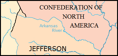
A footnote on page 138 of For Want of a Nail ... mentions that the Mississippi and Arkansas Rivers formed part of the border between the two nations in 1853, at the time of the armistice ending the Rocky Mountain War. This suggests that the Arkansas was established as the border between Jefferson and the confederation of Vandalia at the conclusion of the Trans-Oceanic War in 1799.
By contrast, the border between Vandalia and Mexico del Norte was poorly defined at the time, and remained so for the next forty-five years. It was only after eight years of war and two years of post-war negotiations that a border was finally agreed to in 1855. The frontispiece map suggests that the border departs from the Arkansas River in the foothills of the Rocky Mountains and runs north by northwest until arriving at the confederation of Manitoba near the headwaters of the Missouri River.
The border between Manitoba and the states of Arizona and Alaska seems to run along the eastern edge of the Rocky Mountains until it reaches the Mackenzie River. From there, it follows the river downstream to the Arctic Ocean.